Showing posts with label solo. Show all posts

Saturday, September 8, 2012

8/22/2012 & 8/27/2012 - “What The Hell Are You Doing Here?”

Since about May of this year, I had this trip planned. My Dad's Cousin, Kenny, and myself are (as you know about me) licensed pilots. Well, my father's birthday was August 26. I wanted a nice big surprise for him. So, I thought, since I have my pilot's license, why not go surprise him! That, I did!

The Trip To...

Originally, I was scheduled to leave KRYY on 8/23, but I was able to get the plane early, so I departed from KRYY on 8/22/2012 at around 1PM with 653KB and a full tank of gas. Issues began at first flight. I departed from runway 9, which is the one I really wanted.

Thanks to Google and CloudAhoy, you are able to see my exact course (within reason) thanks to GPS technology (even though GPS Sat 24 has been out of service for about 12 months now, that's not really going to affect me any.) Below the big blue line was my course from KRYY to KPTB. A 400+ mile trip...


I was able to get to a cruise altitude of 3500 feet... for awhile. Headed northbound knowing that there were storms in the North Carolina area that I was going to have to look out for.

I was able to get flight following all the way from Cobb to Petersburg. When I flying north of Greenville and Spartanburg, I did see towering cumulus forming around me. This was a bad sign as they started to get lower and the turbulence started to pick up. Just south of Cleveland, SC I had cumculonubus storm clouds on both sides of me, but at a far enough distance to keep it legal for me to fly. At all times, I was still in the legal parameters to fly VFR.


Over Lake Norman, ATC advised to me: "653KB, at 1 o'clock you will see traffic, a Boeing 757." I was still at 3500 and he was at 4500 descending to Charlotte. He was so close to me, I could easly read: "US Airways," and see which shades were open and not. A few moments later, "653KB, at your 11 o'clock you will see traffic, a Boeing 757." ANOTHER US Airways Boeing landing. I was also given wake turbulence warnings, but was not hit by any. After passing Lake Norman, I had to start to descend to avoid the clouds, with ATC's permission, I went to 3,300 feet.

Near Salisbury I had a major traffic alert. An aircraft took off from KRUQ and was cutting in front of me... he came out of nowhere... even ATC was caught off by surprise. "(alarm blaring in the background) ... (screaming, and fast) 653KiloBravo... Traffic Warning! Traffic Warning! Fast approaching aircraft at your 1, moving right in front of you, your altitude. Take invasive action!" Me... calm voice "Have the aircraft spotted... taking action. 653KB." Right when ATC had called my aircraft I had the plane spotted. I was able to keep my distance from him. It was pretty intense.


Just southwest of Greensboro, I had to descend to 3000 due to clouds. At all times through this flight, I must mention, I stayed VFR and remained within the FAA legal limits. At no times did I break any FAR rules. Now, when I was approaching Greensboro airspace, I was told, that I didn't have permission to enter their airspace. I was going to have to go around it. That's no problem. But, if you notice below, around the "85" Interstate marker, I got pretty close to Greensboro. What happened was, there was a strong shower right in my path, so ATC gave me permission to divert into their airspace to avoid that area. After passing it, I got back on track over Burlington, and continued my route to Petersburg.  


When I entered Virginia, you can see that I followed I-85 for awhile. Not intentional, it just happened that's what my course was. When I entered southern Dinwiddie I broke off as I was 15 minutes out and had the airport in my sight. I called Washington Approach to them know, and to end my flight following and switched over to the Traffic/Advisory Frequency for KPTB (122.7)


Winds were favorable for runway 5. So passed over Sutherland and a bit of Lake Chesdin. Over the rock quarry, and motorsports park, and made a smooth landing at KPTB.


Kenny was able to get my father to the airport 30 minutes before I landed. When I stepped out of the plane, I was greeted with "What the hell are you doing here?" As he wasn't expecting me to be in the plane. (Kenny told him, he had bought a plane, and it was being flown in.) It was a great birthday surprise for him.

While in Virginia, I was hoping to take both Kenny and Dad on a flight. I was planning on going to Manteo, NC (Nags Head) but both days we were planning on flying, the weather wasn't going to allow it.

I was orginially suppose to return to KRYY on the 28th, but due to a cold front/stationary front drapped over the area and with Tropical Storm Isaac coming in from the Gulf bring more mositure and strong winds it was decided to actually come back on the 27th. Good move, because from NC to FL is drapped in IFR conditions.

Current METAR as of this writing:
KRYY 281147Z 08008KT 6SM -RA BR OVC010 23/22 A3004

Current TAF as of this writing:
KRYY 281141Z 2812/2912 10009KT P6SM -SHRA BKN006 OVC010
     FM281500 09012G18KT P6SM VCSH SCT010 OVC020
     TEMPO 2820/2824 4SM -TSRA BKN025CB
     FM290000 11005KT P6SM VCSH SCT020 BKN040
     PROB30 2900/2906 5SM -SHRA
     FM290900 10004KT P6SM VCSH BKN008 BKN015
So, yeah, it was a good decision to come back yesterday instead of today.

The Trip Back...

Due to a technical error, some of the return flight wasn't captured.

Due to a somewhat low ceiling my intended cruise alitutde was 4500, but I only made it to 2500.

Unfortunately, at that height, ATC lost me on radar when I got near the Virginia board. I was told to call Durham in about 10 miles to see if they could pick me. Luckily they did. I prefer to have an extra eyes in the sky. The photo below is a dam, I believed, associated with Lake Gaston. Below that photo is another of an old rock quarry northeast of Greensboro.


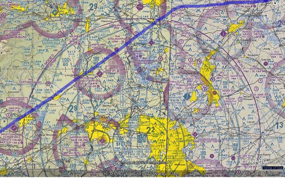
The two maps below are associated with this paragraph. So going back, I'd have to go through the Charlotte Airspace again. I couldn't be promised it due to traffic volume, so I decided to go north of it. Well, when ATC saw my turn to the west, as presented below, they question what I was doing. They then told me, I could go through the Class-Bravo airspace if I wanted. This would save me about 20 minutes. I took them up on the offer, and you can actually see the sharp line to the southwest that I took. The map, is a VFR Sectional of the airspace that I cut through.


Just west of Spartanburg, I saw these birds flying up at me. I was thinking they were going to go back down or fly pass. Well, they did, except one. One small bird flew directly into my wing. I felt the shutter of the plane, and heard the sound of the bird hitting the metal of the plane. I started scanning my instruments for any abnormalities, felt the flight controls... everything was good, seeing if I was leaking gas, etc. After I determine that everything was still good, I tried to look forward as much as I could to see if he was still stuck on the wing or if there was any damage. I couldn't see any. The photo below the map, is a antenna farm on top of Paris Mountain. (I believe that's the mountain.) At this time in the flight, I was hitting a ground speed of about 130 or so knots. We were traveling!


Over Lake Keowee (upper right on the map below) flew right over the Oconee Nuclear Power Station.


My approach into KRYY...

Overall, I was extremely happy with the trip. I was pretty happy with my piloting skills, and my cockpit management skills. Would I do it again? Yes, but I have definitely learned that I need to get my IFR rating.

Happy Flying!

Monday, April 9, 2012

The Toothache Flight – 4/9/2012


Well, we are about a week and two days out from my Pilot's exam. I'm getting very nervous, anxious, and excited. Yesterday, I went up with the instructor and did turns-around-a-point, soft & short field landings, and emergency landing with no flaps but with a slip to land.

Turns-around-a-point seems to be a major weak spot for me. I find it fascinating that in some ways, you don't want a windy day to do these procedures, as it makes it a bit harder, but the landing procedures you want some kind of wind as it makes landing distances shorter. On the day of the test, I would prefer to have winds at 260 between 3-7knts. No gust!

Last night, I was woken up by a very sharp pain in my lower sinus cavity. It felt swollen, so I thought it was a sinus issue. I had a teeth cleaning today, and told the dentist about it, it turns out to be an infection that I will need a root canal done on. That will be this Thursday. He gave me some medicines to take in the mean time. I drop those off at the pharmacy and took off for the airport. (No pun intended.)

The tooth wasn't hurting that much, so I decided to go ahead with my planned flight to KRHP today. While getting ready and prep'ing the plane, winds were calm at KRYY and about 3knts at KRHP. Winds aloft were brisk, but not too bad.

I filed my flight plan, and off I went. Since KRHP and KRYY are on two different sides of the aviation maps we use, I decided that I would use KCNI as a good checkpoint as it was easy to find on both sides. Went to an altitude of 5,500 feet for my flight up there. Past KCNI it started to get bumpy and gusty. At times it was hard holding my altitude. Started to descend into KRHP with winds around 12 knots. I first did a “normal” landing, which was decent. Next was a soft field take off, followed by a short field landing, followed by a short field take off. Next was a normal landing and I decided to take a quick break at their FBO. I grabbed some water, and played with the Andrews-Murphy FBO's TSA Cat. Have no idea what it's name is, but the folks there allowed me to pet her. She was so soft, fuzzy and friendly.

Decided to do a short field take-off again. One thing that is drilled into your head about short field take offs, is when you bring the flaps up from 10º to 0º, you make sure you have plenty of altitude and you have a positive rate of climb. When I bought mine up, my plane took a pretty good dip. Probably due to the wind/gust picking up. On my way out, I thanked Andrews-Murphy for their hospitality, and was welcomed with a “Come back and see us again!” which was very nice. Another Cessna was coming into the area, so we were communicating with each other trying to figure out where he was, and where I was. He was descending, and I was ascending. We kept giving position reports to make sure we weren't going to collide with each other. I never saw him, and he never saw me, but there was no issue. Flying back to KRYY, the chop was getting worst, and that's when the pain started. It's advised that you don't fly when you have a toothache, or sinus problem. Well, the pressure at 6,500 started to affect my tooth. It didn't get too bad, but there was pressure there.

The flight back to KRYY became more turbulent also. I decided that I needed to file a PIREP, and wrote down all the information that I needed. Landed back at KRYY with a normal landing and closed out my flight plan plus filed my first Pilot Report! (Screen shot of it below!)


Overall, it was a good flying day. I have part 2 of my mock-oral tomorrow with Hutch. Saturday went really well, hopefully tomorrow will too (about to study again.) Have my root canal on Thursday, flying with the instructor on Friday and Sunday.

Happy travels!


 A beautiful Cirrus. The photo doesn't do it justice. Love the shiny silver on her.


653KB at KRHP


Friday, March 2, 2012

Long Solo Cross Country – 3/1/2012


Well, after many delays due to weather, I was finally able to finish my solo cross country work. Thursday was a fun flying day. The weather started off kind of nasty, didn't think I was able to go up, but was able to.

If you've ever seen the movie “Airplane,” and know the line “I picked the wrong day to quit smoking.” Well, today would have been “I picked the wrong day not to take Dramamine.” I should note, that I don't take Dramamine before I fly. If you had a weak stomach Thursday, wasn't the day for you to go up.

Thursday I took 707PD up for a spin for my long solo cross country, which had to be at least 150 miles, with at least three stops, one had to be at an airport with a control tower. Took off from runway 28 at KRYY, had to extend my upwind for about 3 miles but was able to bank right and head on my course and go to my cruising altitude of 5,500. When I called the Flight Service, and when I opened my flight plan with the Macon Flight Service Station, I was warn of moderate turbulence below 8,500 feet. They weren't stretching the truth!

As I passed over Allatonna Lake, the plane was bouncing around lightly, nothing too major. As I got closer to my cruising altitude it got rougher and rougher. As I passed “Alert Area A-585” near Sugar Hill, I started to experience Moderate to at some points Severe Turbulence. At one I actually left off my seat a bit before the seatbelt locked, my feet came off the rudder pedals, and I felt my bum lift off the seat. It was rough. A good challenge though. It's weird that in a way, I enjoy turbulence, but I respect it. When I start IFR training I will have to see how much I like it then with my “Foggles” on. When I passed West of Blairsville Airport (KDZJ) the turbulence let up. Had a successful and quite smooth landing at KRHP (Western Carolina/Andrews, NC Airport.) Since taxiway Alpha 1 is still closed, I had to make the announcement on the radio that I was taking to the active runway, and will do a 180.

Took off from KRHP for a cruising altitude of 6.500 heading to Pickens County (KJZP.) Never been to KJZP before, so it was a nice change and something different too. Flying there wasn't as bumpy as going from KRYY to KRHP, but there were times that it go bumpy. Had a bit of a tricky landing on runway 34, as the crosswind was very close to the maximum demonstrated for my Cessna. I had lined up for the center line on the runway, but due to the strong crosswind, I was a little off by the time I landed. Nevertheless, all three wheels touched the ground safely, and taxied back to the start of runway 34 to head back to KRYY.

It was time for me to head back to KRYY, so took off from runway 34, and went to a cruising altitude of 4,500 feet. Again, not much turbulence, but there was some. When I took off from KRYY earlier in the day, the METAR for KRYY at 1646 Zulu was winds 280 @ 6knots. By the time I was flying back, winds were coming straight down the runway at 290 but at 12 knots with gust up to 23. Now, the good news of it all was that it was pretty much down the runway so I didn't have to deal with crosswinds, but the (potential) problem was the gust. At one point during the landing portion, I felt the plane losing altitude too fast, and was able to give it some power before a problem were to occur. Well, I used the winds to my advantage to kill some of my speed and aerodynamic breaking on the runway, so I was actually able to exit off Alpha 4 instead of the usual Alpha 3. Nevertheless, landed safely and that ended my trip for the day. 

So, since all my cross-country solo work is done, and I've finished the 10 hours of solo flying needed; it's now time for me to get ready for my check-ride with the FAA Examiner and the Oral portion of the test. On Tuesday (weather permitting) I'm going to do some solo work, and on Wednesday my instructor and I are going to go up and will be doing the maneuvers that I will have to do for the Examiner.

Below is the route that I took for my Long Solo Cross Country (KRYY-KRHP-KJZP-KRYY.) Map provided by Skyvector (Click on link for bigger picture, and to take a look at the site!)


Here are two Pilot reports (translated for Non-Pilots) that were reported by other pilots in the area I was flying in on Thursday:

PIREP – 3/1/12 – Flight Level 7,500, Type BE36 (Beechcraft Bonanza 36,) Turbulence Moderate to Severe
PIREP – 3/1/12 – Flight Level 7,000. Type C25B (Cessna 525B Jet... interesting note, I actually saw this guy when I was flying to KJZP,) Turbulence Continuous Moderate to Severe Chop

Interesting note about today's (Friday 3/2/2012) weather. The Storm Prediction Center has placed us under a Tornado Watch until 12AM Saturday. Yesterday (Thursday 3/1/2012) I turned on my AC for the first time this year, and today it's still on. As of this writing (6PM on 3/2/2012) it's 76 with a heat index of 78. Today's high was 76, and yesterday it was 77.

The two maps below are from the National Weather Service in Peachtree City for the severe weather tonight (Firday 3/2/2012)


The map below is from the National Weather Service Website. Yellow is current Tornado Watches, and Red is current Tornado Warnings.


Below are the prediction maps from the Storm Prediction Center


Keep ya seat belts on, it will be a bumpy right tonight in the sky and on the ground!

Thursday, February 23, 2012

Why I Didn't Fly Today...

Here is why I didn't fly today, these are the METARs from KRYY (Cobb County, base airport) KRHP (solo cross-country airport,) and KAHN (secondary solo cross country airport):

KRYY

11AM - Winds 220 @ 11 Gusting up to 18
12PM - Winds 220 @ 12 Gusting up to 20 ... Winds vary between 170 and 250
1PM - Winds 200 @ 14 Gusting up to 22
2PM - Winds 220 @ 14 Gusting up to 24... Winds vary between 170 and 250
3PM - Winds 210 @ 14 Gusting up to 26... Winds vary between 170 and 250
4PM - Winds 210 @ 13 Gusting up to 25... Winds vary between 180 and 270

KRHP

11AM - Winds 240 @ 10 Gusting up to 15
12PM - Winds 220 @ 13 Gusitng up to 17
1PM - Winds 240 @ 15 Gusting up to 20
2PM - Winds 220 @ 10 Gusting up to 25
3PM - Winds 230 @ 17 Gusting up to 24
4PM - Winds 220 @ 12 Gusting up to 23

KAHN

11AM - Winds 240 @ 11 Gusting up to 21
12PM - Winds 240 @ 11 Gusting up to 17
1PM - Winds 230 @ 10 Gusting up to 24
2PM - Winds 220 @ 12 Gusting up to 26
3PM - Winds 210 @ 12 Gusting up to 26.

PIREP

PIREP 22:19Z 02/23/12
RYY UUA /OV KRYY/TM 2219/FL004/TP BE40/RM LLWS +20KT 400 AGL FAP RWY 27


So, never the less, it would've been a very bouncy day up there today. Tomorrow and Saturday looks like a no-go also due to winds and weather. Will keep ya posted. Hold on to your hats out there!

Possible Grounding?

Well, with this being a 3-day weekend (Thursday, Friday, and Saturday,) I was really hoping to get some flying in. I was hoping to finish up my long solo cross-country, and start preparing for my check-ride.

Right now, looking at the weather forecast for KRYY the next several days, looks like I’m ground on all three due to winds (and some weather):

Thursday – Fog before 7AM, cloudy otherwise then gradually becoming mostly sunny. Winds Southwest at 5-15 with gusts up to 20.

Friday – Chance of showers and storms before 1PM, then mostly cloudy. Winds West around 10 with gust 20.

Saturday – Sunny. Winds Northwest between 15-25 with gust as high as 35.

The thing that seems to be grounding me is the winds. Have student solo restrictions on me of Winds up to 10, and crosswinds of 7.

Also, for today (Thursday) when I would be doing my cross country solo work the winds at the levels I would be flying would be: 6,000 feet – 260 @ 38knots 9,000 feet – 260 @ 51knots

I’m still planning on going to the flight school at 10AM today and just seeing at that time what it looks like, but more than likely, no-go for this weekend at all.

As we all know with weather, it can change in a heartbeat.

Sunday, February 19, 2012

A Flight To The Mountains – 2/17/2012


Well, a couple of things have happened since my last post. On 2/16/2012 (Thursday) I went into the flight school to take a pre-test for the Written, and passed it. While talking to the dispatcher about it, and my high test anxiety, I decided to go ahead and take the test that day. At 12:05PM, the test begun. Now mind you, that I have one of the worst test anxieties out there. I've actually lost sleep over this test, I'm more of a projects person, hands on. Give me a project, or something that I can use my hands, and I'll pass it with flying colors. Well, as I mentioned, I did take the test, and PASSED! I didn't get the high score that I wanted, but the main thing is that I passed. I didn't pass on the low end of the scale, so that made it a tad bit better. I just wonder how the examiner will take it during the Oral part of the test. The main thing is, I PASSED! We'll cross the Oral part of the test when we get there, taking a small break this weekend from studying, but will continue to study, now for the oral, starting on Monday.

Thursday was a bad day to fly anyways, it was raining, and pretty heavy at times. So, it was a good day to take the test. On Friday, it was a different story...

Friday, was beautiful. Sunny and warm. It was the perfect definition of flying weather. Winds were out of the north at around 5 or so. And I had scheduled to go up at around 10AM to do a cross-country. Well, an unexpected appointment came up at 11:15AM, so I couldn't do my cross-country at 10AM, so I moved it to 12:30PM. As the Pilot-In-Charge, that was a great decision, the location I was going to, was socked in with fog. They were reporting Fog, with overcast clouds at 100 feet, and ground visibility at ¼ Statute miles. But as the morning went on, the fog started to burn off, and by the time I was getting ready for my flight, they were reporting winds at 230 @ 5, and clear skies! Off to the Mountains of North Carolina, Off to Western Carolina Regional (KRHP)!

Took good ol' 653KB up to about 5,500 feet. Flew over Allatonna Lake, which was very blue. Flew just east of Canton, and right over Nelson, GA, heading for the mountains. As I started to get close and over the mountains, the turbulence started to pick up. I would say it was Light Chop with moments of moderate turbulence. This mainly happened over “Alert Area A-685,” which is a 25 mile military zone. The highest mountain in that area is 3,767 feet, so I still had plenty of room. Passed three miles west of Blairsville, and off my nose at 12 o'clock was KRHP. KRHP is in a valley between 3 mountains ranging in 5,000 feet range. The airport is located at 1,697 feet. So as you are going through the valley, there are 5,000 feet mountain ranges around you. The real butt clincher is when you are turning from base to final onto runway 26, all you see through your windscreen is mountain. You are very close to a mountain. Landed safely at KRHP, and decided to take a break... my bladder was full. So, while I was out, took a couple snapshots, which are below.

Headed back into KB, and taxied to the runway. Unfortunately, a majority of their taxiways are closed, so I had to announce, and made sure any incoming aircraft knew, that I was going to take to the runway, and taxi to the end of it, do a 180, and take off from there. I wasn't planning on doing a short-field take off, especially with those mountains around, I wasn't going to take a chance.

Took off from KRHP with no issue, and was heading for an altitude of 6,500 feet. While cursing at 6,000 still climbing, I had my left hand on the yoke, my paperwork and maps on my lap, and my right hand on the throttle, about to power down... when all of the sudden, I felt something on my left arm. Knowing that I'm at around 6,000 feet, and knew there shouldn't be anything on my arm, I looked down, and there was a big wasp on my arm. Not knowing if I'm allergic to bee/wasp stings, I decided to do what any pilot would do... fly the plane. In the mean time, I leveled off, took the map, and swatted him like a baseball! Luckily he didn't sting me, because if he did, I would of more than likely had to land at Blairsville (KDZJ) or fly an additional 25 miles before I got to Pickens (KJZR) for safety. I can just hear me talking to Atlanta Center, with all the professional airline pilots on the same frequency, and telling them my intentions due to a wasp sting... embarrassing! Main thing is, it didn't sting me.

Landed safely back at KRYY, and that ended my flying adventure for Friday!

On Tuesday, I'm planning to go up, and do some practice with Steep Turns and more landing practices. Steep turns make me nauseous, so I need to get my body use to it. You try and do a 360, at around 2500 feet while at a 45 degree bank and see what happens to you. On Thursday, I'm planning on doing my “Long Cross-country,” which will take me from KRYY to KRHP (Western Regional) to KJZR (Pickens) back to KRYY.

Enjoy the photos below... See ya in the skies!

 653KB chillin' out at KRHP

TSA Security at KRHP... KITTY KITTY KITTY!

The FBO at KRHP 

Looking towards the South/Southwest. Have to fly over those mountains to get back to KRYY

Looking towards the South/Southesast.

Wednesday, February 15, 2012

To Athens, No, The Other One... - 2/15/2012


Headed Eastward today to Athens, GA (for the 3rd time.) My second solo cross-country trip. Is uneventful a good thing? Sometimes, but when you are piloting a plane, it definitely is!

Taking off from runway 9 at KRYY, we had a wind at 120 @ 5kts. Nothing major, really didn't feel it while taking off either. Flew eastward at 3,500feet. Smooth as silk. Going to Athens, didn't see any other aircraft in the area. I was only given one traffic advisory, but didn't see him (he was below me anyways.)

Landing in Athens on runway 9 was decent, it seemed a bit bouncy, not wheels leaving the runway bouncy just... well, it didn't feel like a normal landing. It wasn't a high flare landing nor a low one, not really sure how to describe it. Taxi back to the start of 9. There is this lady in ATC, who I've talked to before, who has an awesome personality. Very friendly, kind of brings a smile to my face. You can tell she enjoys her job.

Leaving Athens, flew westward at 4,500feet. Again, smooth until I was about 15 miles from Cobb County Airport, or about 5 miles north of KPDK. It started to get bumpy up there. Was given two traffic advisories... One was for another Cessna landing at KPDK, and another was a C-130 coming straight at me landing at Dobbins. We were both descending, so we saw each other. There was no conflicting issues with spacing, we were far enough away, but still, he is huge!

Landing on runway 9 at KRYY was a bit of a challenge. While landing, winds started to pick up, and we had a recorded gust of 14 knots. Unfortunately, it made for a bounce landing, the second part of the landing was what a landing was suppose to be like, but the first part ticked me off. All pilots have their “not perfect” landing, but when the FAA Examiner is in there with me, it needs to be perfect!

So, what's next? Tomorrow, Thursday, I was going to do some solo work in the area, but due to weather moving in, I'm going to cancel it. Instead, still going into the flight school, but will be doing a practice written test. If I pass that with an 80+, I'll be signed off to take the actual test. These test are haunting me, I've already started to dream about them. I'm not a good test taker, I'm more of a project type person.

So, I need to get 5 hours of solo cross-country time down, right now, I'm right below the limit, so I need to get one more flight in. I'm thinking it will be Friday, and heading up to North Carolina for that one. Winds are looking good, North @ 5.

Happy Flying!

Thursday, February 9, 2012

Adventure Flight to Choo-Choo – 2/9/2012


Today, I'm proud to announce that I did my very first Cross Country Solo trip. It was successful but adventurous! It was a standard start to a flying day. I got the weather reports, worked on my flight planned to Chattanooga, and had my instructor look over everything and did one final briefing. I called into the local Flight Service Station to file my plan and to get a weather briefing, pretty standard, but there was some kind of air-drop happening just Northwest of Rome, I was advised on it, but it didn't affect me at all... I am curious what was being dropped. I headed out to good ol' 653KB... advantage: Both magnetos work without having to clear the right one. Disadvantage: No autopilot, but not having autopilot or a Glass cockpit makes a real pilot out of you, and I had neither.

Taxied out to Runway 9, and took off for an altitude of 4,500. About 5 miles Northwest of KRYY, I had to open my flight plan, called Macon Radio (Flight Service Station) to open it, but they didn't answer, so I had to call on a different frequency, not the most clearest in the world, but still understandable. After talking to them, I called into Atlanta Center to get a Flight Following. As a VFR pilot, it's highly recommended that you get a Flight Following in case something goes wrong, plus you are in immediate contact with Air Traffic Control so they can get emergency services going. When flying VFR, you do it in two ways: Pilotage, and Dead-reckoning. (Remember those two.) Piloting is when you use your maps, checkpoints and magnetic heading to get to your destination, and Dead-wrecking is when you use mathematics to get to your destination. So, I had 3 checkpoints on my way to KCHA, they were the Town of White, Power lines 3 east West of Calhoun, and water tanks west of Dalton, near an I-75 exit. Based on mathematics, it was going to take me 36 minutes and 57 seconds to get to Chattanooga. About 37 miles out from KCHA, Atlanta Center had me switch over to Chattanooga Approach, and stayed there for the rest of my trip. About 5 miles north of the Water Tanks checkpoint, I was told to turn and stand by for further vectors to the airport. In the mean time, the ceiling (the bottom of the clouds) started to get lower and visibility started to drop from 10 miles to about 6. About 7 miles out from KCHA I could see the airport, and was cleared to land on Runway 2. Very uneventful landing, taxied off, and taxied back to the beginning of the runway. Got all my paperwork ready and I called out to Chattanooga Tower, and informed them I was ready to take off.

I was given the clearance to take off, and to remain runway heading (don't turn) and be advised to switch over to Chattanooga Departure shortly thereafter. Powered my little baby up, and headed out. Was given clearance to turn to my intended heading, and switch over to Departure. Departure gave me clearance to go to 3,500ft, stay VFR, and to remain on my heading. Based on mathematics, it was going to take me 34 minutes and 22 seconds to get back to KRYY, that was about to be blown out the window. A few moments later, they told me that I needed to change my heading and stay on the heading until further notice due to traffic coming in. So, I turned to the heading they told me to, and continued on my way, waiting for them to tell me to head back on course. Well, apparently, they forgot about me. After awhile, they told me that I could turn back on course. The issue was, I was off course now, and missed my first checkpoint heading back to KRYY. My first checkpoint was a Dam, followed by Power lines 3 miles east of Calhoun, the town of White, and Altonna Lake. Well, the dam is behind a mountain ridge which is now obscured due to haze and the mountain itself. Dead-reckoning is now out of the question, and now it's up to Pilotage... but only with the map. So I started to pick out land features, that were also seen on the map I had. I was able to get west of the Dalton Airport, and stay on that course until I saw the Calhoun airport, the associated power lines. After the power lines was the town of White, which I was able to fine tune in my course better, and come straight into KRYY. If I just used my course after Chattanooga Departure told me to return to course heading, I would have been way off course. I got clearance from KRYY Tower to come in on runway 27, I was number 1 in the lineup, with no rush. While on approach to 27, at 2,000 feet, I saw something that I hadn't seen before: A plastic bag! Well, I've seen a plastic bag before, but this one was at my altitude floating along. Great, just what I need, my pitot tube gets blocked by a plastic bag... Haha...

Going to Chattanooga, winds were okay, but coming back, I was getting bounced up there. One thing I really would like to learn more about is PIREPS, who do we give them to, the Flight Service Station or Air Traffic Control, really thought I should of gave one today due to the turbulence up there.

Next cross country solo flight is schedule for the 17th, which will probably be to Athens, GA. Looking at weather models, it looks like winter might be returning, so need to get as much done (flying-wise) as possible and wrap up the bookwork, which I plan to wrap up this week.

Some people have asked, “Cross country trip, you mean you go across the country?” My wish is yes, but that would be very expensive. Per FAA Regulations, this is what a Cross Country Trip means: 61.93(a)(i) Conducting a solo cross-country flight...that is greater than 25 nautical miles from the airport from where the flight originated.

Below is a map of my route today: Pinkish line is my "intended heading." Baby Blue line is my course up to KCHA. Red Lines are my checkpoints to KCHA. Green Lines are my checkpoints to KRYY. The Black Line is my route I actually took coming back to KRYY (not a true-true showing, but close enough.)


Two FedEx MD-11s chillin' out at KCHA. I wasn't able to get their tail numbers, but I know they are part of the MD family.


Wednesday, February 8, 2012

The Word Of The Day Is: Choppy! - 2/8/2012

Today took 653KB out for a spin. While getting ready to take-off, got a weather report that winds were at about 9knots from 300... right on the edge of my limitations as a student pilot. I was given the go-ahead to take off, just be careful, and if it gets rough, come back in immediately. I headed out to the NW to the practice area SW of Cartersville Airport, and direct south of the power plant. I decided to do a couple maneuvers, the main one being steep turns. Did a couple of them, but I need to go back and review the procedure as it's been awhile... also got a little motion sickness. (You go around in a 360 at a 45 degree bank with turbulence, and see how you feel.) So I decided to head to Cartersville to do so practice landings. Winds were at about 340, so there was a crosswind, and runway 1 was in use. I was actually the only one in the pattern around the airport.

First landing was okay, kind of botched the crosswind landing technique, but still got on the ground safely. The second landing was fine, but take off got worrisome. The winds were still at about 340, but two hundred feet off the ground it switched to 300 very quickly, and several hundred feet later it was 320. The average winds were between 300 to 350. (Directionally speaking.) Different layers of the atmosphere, even close to the ground was experiencing winds coming out of different directions. Landing number three was successful with no issues. Decided to head back to KRYY as it was time for me to return the plane and head out to lunch with a buddy of mine.

Going from KVPC to KRYY, I had one bitching tailwind. While I got clearance to land on runway 27 at KRYY, I had a stipulation from Air Traffic Control, they were going to give me the number 1 spot in landing, but I had to keep up my airspeed until the last minute due to a jet on my tail coming into KRYY. Kept up speeds (within regulations of course.) And had a very successful crosswind landing, also kept my speed up on the runway so I could get off at Bravo 3, so the jet could land behind me.

All-in-all it was a good day, but choppy. Now, I have been through a lot of chop before, but this time was my first time soloing with a lot of chop. I believed I handled it pretty good. Overall, one thing I need to be more mindful of is my altitude, it needs to stay constant, instead of fluctuating. Overall, I think the issue today was mainly the gusts.

So, tomorrow... big day! Well, let me step back for a moment, on Tuesday, I went into the flight school for my stage check with Hutch on doing my solo cross-country. Pretty much aced it, but he did give me a couple suggestions, which I do appreciate. I was given the all clear to start my cross-country solo, and that will be tomorrow, Thursday!

Tomorrow, will be heading out to Chattanooga for my very first solo cross-country. I was asked by a friend of mine if I'm scared... I'm not really scare, more nervous, and excited. Based on wind profiles for tomorrow, I'm predicting going up there will take about 38 minutes, and coming back will be between 33-35 minutes. Winds should be much lighter tomorrow, right now KRYY is predicted to have winds out of the northwest at around 6, and KCHA is predicted to have winds out of the north at 5. (No gusts.)

Will of course talk about my cross-country trip tomorrow... in the mean time... happy flying!

Straight line of clouds moving out... was preping the plane when I snapped these shots.


Friday, February 3, 2012

Final Night Flight – 2/2/2012


Well, after some delays due to weather, I got my final 8 landings completed and finished my required 3-hours of night flight. Pretty uneventful. 707PD and 653KB were both unavailable, so I used the 1980 172 Cessna N53361. I hadn't flown her before, so it was a new experience in a way. I really love the Garmin GPS in her. I really wish it was that GPS in PD & KB, but I'm not going to look a gift horse in the mouth.
Originally was schedule to do my night flight yesterday (2/1/2012,) but it got canned due to weather. We had a system move through the area, and the rain was pretty much gone by 6PM (our planned take off time) but conditions went to IFR and even LIFR passed it, so we just moved it to today.
The first landing of the night was kind of rough, flared to high. We just took it that it had been awhile since I flew at night which is the reason for the high flare. We did one landing with no taxi or landing lights (per approval with KRYY Tower.) Actually landed perfectly on the center line. That was really interesting trying to judge it based off instruments, and the surrounding lights. By the 7th landing, all was well. The issue became that we still had 40 minutes that I needed to get logged for night flight. So we decided to head over to Cartersville, GA Airport. At first we were debating Cartersville or Paulding, but Cartersville was more favorable due to winds. While flying over there, we noticed that I-75North was completely in gridlock. No cars moving. Apparently there was a nasty accident. We could see the cop cars, but not actually what happened. We got to Cartersville, and entered the pattern. Another company aircraft was there: N966SA, he was doing night procedures also. Landing in Cartersville wasn't too bad, only that the pilot for SA had turned on the landing lights too high which gave us a horrible glare, but we landed safely. While taxing off the runway, we did turn down the runway lights down a notch.
While taking off from Cartersville, at around 1,000 MSL I noticed we started to have a problem with the aircraft. I was loosing airspeed (at one time I was around 60knots,) and the altimeter had stopped moving... it wasn't falling nor was it rising. The control of the aircraft seemed fine, I didn't feel any signs of a stall coming and there was no sound from the Stall Indicator. I just leveled off the aircraft and the airspeed caught up. Not really sure if it was a system issue or a high attitude issue. I wasn't at a nose-high attitude based off instruments, so I'm going with a system issue. Probably a bug or something got into the system. We took off from runway 19 at Cartersville, so it was all dark (trees) in the area, so it was kind of hard getting a visual at how high we were. We returned to KRYY for a safe landing, and completed the required flight hours and night landings per the FAA.
So, what's next? On Saturday, I need to report in for a 2.5 hour ground lesson (will probably be much shorter) but have to plan out my first solo cross-country. My instructor and I will go over density altitude (a refresher) and look over where I'm going for my cross-country. I have decided to go back to Chattanooga. After Saturday's lesson, I have a solo flight planned for Sunday afternoon. Right now that is up in the air... why? Well, guess... of course, the weather. We will see what happens. Early next week, I'm suppose to meet up with Hutch and go over more cross-country planning procedures (it's a stage check.) And hopefully next Wednesday or Thursday I might be able to do my first solo cross-country trip. If not this coming week, it will be more than likely be the following week. I've already started planning out my 150-nm/3 airport landing solo cross-country. I'm thinking about KRYY-KCHA-KRHP-KJZP-KRYY (Cobb, Chattanooga, Western Carolina Regional, Pickens Co, Cobb.) We will see about that as we get closer.
As for the written test, it's going well. I sent my issues with math to a good buddy of mine (John) to see if he can help explain it to me a bit more. He's a good teacher. Otherwise, studying the book, taking practice test. Planning on taking the written at the end of this month. Had a dream the other night, that I failed my FAA Check-ride... what a nightmare! Hopefully that's all it was, a nightmare!