Severe storms (a derecho) moved across Virginia the night of 6/29/2012...
PIREP 02:45Z 06/30/12
RIC UUA /OV HPW/TM 0245/FL350/TP B737/TB SEV
PIREP 02:09Z 06/30/12
CHO UUA /OV GVE225020/TM 0209/FL060/TP E145/TB SEV/RM SEV UPDRAFTS
PIREP 02:16Z 06/30/12
AVC UUA /OV LVL330015/TM 0216/FL340/TP B737/TB SEV CAT
PIREP 02:09Z 06/30/12
SIF UUA /OV GSO030035/TM 0209/FL155/TP CRJ7/TB MOD-SEV 155-130/RM DURD
PIREP 04:12Z 06/30/12
MFV UUA /OV CCV360005/TM 0412/FL070/TP PA31/TB MOD-SEV
FL - Flight Level
TP - Type of Aircraft
TB - Turbulence.
Showing posts with label severe thunderstorms. Show all posts
Showing posts with label severe thunderstorms. Show all posts
Saturday, June 30, 2012
Saturday, March 3, 2012
Paulding Airport (KPUJ) Closed
Per the AJC:
"12:44 a.m.: The Paulding Northwest Atlanta Airport west of Dallas is closed until further notice. Airport manager Blake Swafford told the AJC that 80 percent of the 23 aircraft at the airport were destroyed. "Basically, everything is damaged," he said."
"3:16 a.m.: The Paulding Northwest Atlanta Airport is closed indefinitely after Friday night's powerful storm flipped airplanes over and destroyed the hangar, damaging at least 20 aircraft.
"Basically, everything is damaged," Blake Swafford, the airport's director, told the AJC early Saturday.
Rain continued to fall as Swafford described the extensive damage to the airport, located near Dallas, 30 miles northwest of Atlanta. The overturned planes caused hundreds of gallons of fuel to leak, and firefighters were expected to remain on the scene overnight to apply foam to the area, MaryAnn Phipps with the Paulding County Fire Department said.
Debris was strewn along the main airport road late Friday night, with some metal hanging from trees. The entrance into the airport was blocked due to the potential safety hazards.
In addition to the fuel spill, electrical wiring was left exposed after the storm, also posing a safety risk, Swafford said. The airport will be closed until further notice, but the runway is open in the event an emergency landing is needed, he said.
Out of the 23 airplanes parked at the airfield, Swafford said at least 20 were damaged.
"If we're able to save three or four airplanes, we'll be fortunate," Swafford said.
The airport, the first to open in Georgia in more than 30 years, opened in November 2008 and was still a work in progress. Massive rebuilding will likely be required, Swafford said.
The storm damage comes just nine days after a hangar under construction at the airport collapsed. Christopher Mathis, 30, of Valdosta, died Monday from injuries sustained in the hangar collapse, Paulding County deputy coroner Karen Robinson told the AJC earlier this week.
Officials planned to assess the damage at the airport Saturday morning in the daylight."
When I called the AWOS Hotline for Paulding early this morning, there was no answer from the automated weather station. DUAT is reporting KPUJ Aerodrome is closed. No reports of damage from KRYY. There was a possible tornado (per indications from Radar) about 1 mile north of me in Marietta. No damage here at my place, but I can tell you, that when the possible tornado was in my area, it got very quiet outside, kind of spooky.
Friday, March 2, 2012
Long Solo Cross Country – 3/1/2012
Well, after many delays due to weather, I was finally able to finish my solo cross country work. Thursday was a fun flying day. The weather started off kind of nasty, didn't think I was able to go up, but was able to.
If you've ever seen the movie “Airplane,” and know the line “I picked the wrong day to quit smoking.” Well, today would have been “I picked the wrong day not to take Dramamine.” I should note, that I don't take Dramamine before I fly. If you had a weak stomach Thursday, wasn't the day for you to go up.
Thursday I took 707PD up for a spin for my long solo cross country, which had to be at least 150 miles, with at least three stops, one had to be at an airport with a control tower. Took off from runway 28 at KRYY, had to extend my upwind for about 3 miles but was able to bank right and head on my course and go to my cruising altitude of 5,500. When I called the Flight Service, and when I opened my flight plan with the Macon Flight Service Station, I was warn of moderate turbulence below 8,500 feet. They weren't stretching the truth!
As I passed over Allatonna Lake, the plane was bouncing around lightly, nothing too major. As I got closer to my cruising altitude it got rougher and rougher. As I passed “Alert Area A-585” near Sugar Hill, I started to experience Moderate to at some points Severe Turbulence. At one I actually left off my seat a bit before the seatbelt locked, my feet came off the rudder pedals, and I felt my bum lift off the seat. It was rough. A good challenge though. It's weird that in a way, I enjoy turbulence, but I respect it. When I start IFR training I will have to see how much I like it then with my “Foggles” on. When I passed West of Blairsville Airport (KDZJ) the turbulence let up. Had a successful and quite smooth landing at KRHP (Western Carolina/Andrews, NC Airport.) Since taxiway Alpha 1 is still closed, I had to make the announcement on the radio that I was taking to the active runway, and will do a 180.
Took off from KRHP for a cruising altitude of 6.500 heading to Pickens County (KJZP.) Never been to KJZP before, so it was a nice change and something different too. Flying there wasn't as bumpy as going from KRYY to KRHP, but there were times that it go bumpy. Had a bit of a tricky landing on runway 34, as the crosswind was very close to the maximum demonstrated for my Cessna. I had lined up for the center line on the runway, but due to the strong crosswind, I was a little off by the time I landed. Nevertheless, all three wheels touched the ground safely, and taxied back to the start of runway 34 to head back to KRYY.
It was time for me to head back to KRYY, so took off from runway 34, and went to a cruising altitude of 4,500 feet. Again, not much turbulence, but there was some. When I took off from KRYY earlier in the day, the METAR for KRYY at 1646 Zulu was winds 280 @ 6knots. By the time I was flying back, winds were coming straight down the runway at 290 but at 12 knots with gust up to 23. Now, the good news of it all was that it was pretty much down the runway so I didn't have to deal with crosswinds, but the (potential) problem was the gust. At one point during the landing portion, I felt the plane losing altitude too fast, and was able to give it some power before a problem were to occur. Well, I used the winds to my advantage to kill some of my speed and aerodynamic breaking on the runway, so I was actually able to exit off Alpha 4 instead of the usual Alpha 3. Nevertheless, landed safely and that ended my trip for the day.
So, since all my cross-country solo work is done, and I've finished the 10 hours of solo flying needed; it's now time for me to get ready for my check-ride with the FAA Examiner and the Oral portion of the test. On Tuesday (weather permitting) I'm going to do some solo work, and on Wednesday my instructor and I are going to go up and will be doing the maneuvers that I will have to do for the Examiner.
Below is the route that I took for my Long Solo Cross Country (KRYY-KRHP-KJZP-KRYY.) Map provided by Skyvector (Click on link for bigger picture, and to take a look at the site!)

Here are two Pilot reports (translated for Non-Pilots) that were reported by other pilots in the area I was flying in on Thursday:
PIREP – 3/1/12 – Flight Level 7,500, Type BE36 (Beechcraft Bonanza 36,) Turbulence Moderate to Severe
PIREP – 3/1/12 – Flight Level 7,000. Type C25B (Cessna 525B Jet... interesting note, I actually saw this guy when I was flying to KJZP,) Turbulence Continuous Moderate to Severe Chop
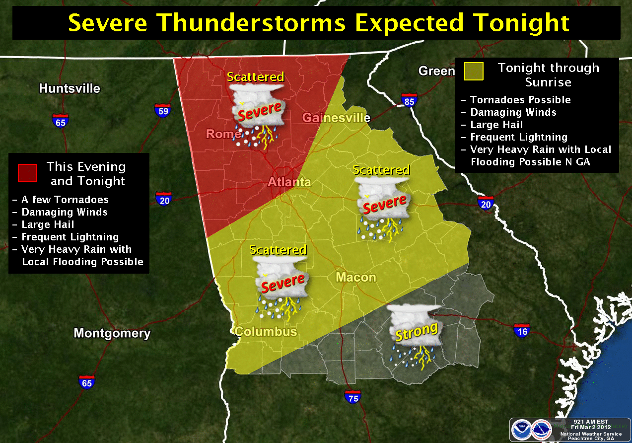
Interesting note about today's (Friday 3/2/2012) weather. The Storm Prediction Center has placed us under a Tornado Watch until 12AM Saturday. Yesterday (Thursday 3/1/2012) I turned on my AC for the first time this year, and today it's still on. As of this writing (6PM on 3/2/2012) it's 76 with a heat index of 78. Today's high was 76, and yesterday it was 77.
The two maps below are from the National Weather Service in Peachtree City for the severe weather tonight (Firday 3/2/2012)

The map below is from the National Weather Service Website. Yellow is current Tornado Watches, and Red is current Tornado Warnings.

Below are the prediction maps from the Storm Prediction Center


Keep ya seat belts on, it will be a bumpy right tonight in the sky and on the ground!
Subscribe to:
Posts (Atom)